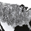
 What you see above is the first satellite photo of the contiguous 48 states of the United States. It was created in 1972 for NASA by a US agriculture department division, and comprises 595 cloud-free photos captured by NASA’s first Earth Resources Technology Satellite. All the photos were captured from the same altitude of 560 […]
This Image from 1974 is the First Satellite Photo of the Contiguous United States
PetaPixel - 16 Jan 2015 18:42
What you see above is the first satellite photo of the contiguous 48 states of the United States. It was created in 1972 for NASA by a US agriculture department division, and comprises 595 cloud-free photos captured by NASA’s first Earth Resources Technology Satellite. All the photos were captured from the same altitude of 560 […]
Share this Article
Recommended