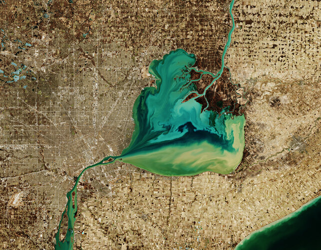
 Image: The Copernicus Sentinel-2 mission takes us over Lake St. Clair, forming the border between Ontario, Canada to the east, and Michigan, US to the west. The Saint Clair River is visible at the top of the image and flows southwards, connecting the southern end of Lake Huron with Lake St. Clair, visible in the centre of the image. The river branches into several channels before reaching the lake, creating a seven-mouth delta. Much of the area surrounding the delta is used for agriculture. The ...
Image: The Copernicus Sentinel-2 mission takes us over Lake St. Clair, forming the border between Ontario, Canada to the east, and Michigan, US to the west. The Saint Clair River is visible at the top of the image and flows southwards, connecting the southern end of Lake Huron with Lake St. Clair, visible in the centre of the image. The river branches into several channels before reaching the lake, creating a seven-mouth delta. Much of the area surrounding the delta is used for agriculture. The ...
Image: The Copernicus Sentinel-2 mission takes us over Lake St. Clair, forming the border between Ontario, Canada to the east, and Michigan, US to the west. The Saint Clair River is visible at the top of the image and flows southwards, connecting the southern end of Lake Huron with Lake St. Clair, visible in the centre of the image. The river branches into several channels before reaching the lake, creating a seven-mouth delta. Much of the area surrounding the delta is used for agriculture. The ...
Share this Article
Recommended